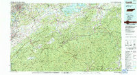
1983 Map of Knoxville
USGS Topo · Published 1984About this map
The Great Smoky Mountains National Park dominates the southern half of this landscape, rising from the Little River valley toward the high peaks of Clingmans Dome and Mount Le Conte. In the early 1980s, the urban corridor stretching from Knoxville through Alcoa and Maryville shows the concentrated development of the Tennessee River valley, including the University of Tennessee and McGhee Tyson Airport.
Find a feature on this map
54 named features on this map. Tap any name to fly to it.
Don’t see what you’re looking for? This feature index may not catch every label — zoom into the map to look around manually.
Map Details
Editions of this 1983 Knoxville Map
This is the sole edition of this map. No revisions or reprints were ever made.
Other maps of this area

1883 · Morristown
USGS Topo · 1:125,000

1886 · Knoxville
USGS Topo · 1:125,000

1891 · Cowee
USGS Topo · 1:125,000

1892 · Greeneville
USGS Topo · 1:125,000

1892 · Knoxville
USGS Topo · 1:125,000

1893 · Mt Guyot
USGS Topo · 1:125,000

1893 · Morristown
USGS Topo · 1:125,000

1893 · Murphy
USGS Topo · 1:125,000

1893 · Briceville
USGS Topo · 1:125,000

1894 · Asheville
USGS Topo · 1:125,000