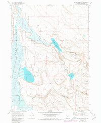
1967 Map of Krumbo Reservoir
USGS Topo · Published 1980About this map
Malheur National Wildlife Refuge dominates this section of Harney County, illustrating a complex hydrological system designed for habitat management in the high desert. The Blitzen Valley floor is a network of managed water features, including the Krumbo Canal, Warm Springs, and the Blitzen River, which feed into larger bodies like Baca Lake 4154 and Knox Pond. The human footprint is defined by the Witzel Ranch and infrastructure such as the Krumbo Reservoir Spillway and a remote Landing Strip. These features reveal how the landscape was engineered for both ranching and conservation during the mid-20th century. Beyond the wetlands, the terrain rises toward volcanic landmarks like Krumbo Butte and the curiously named Dutch Oven depression, while numerous Borrow Pits and Prospects suggest local mineral exploration and material extraction for road maintenance like the Patrol Road.
Find a feature on this map
29 named features on this map. Tap any name to fly to it.
Don’t see what you’re looking for? This feature index may not catch every label — zoom into the map to look around manually.
Map Details
Editions of this 1967 Krumbo Reservoir Map
2 editions found
Other maps of this area

1955 · Burns
USGS Topo · 1:250,000

1955 · Adel
USGS Topo · 1:250,000

1957 · Adel
USGS Topo · 1:250,000

1958 · Burns
USGS Topo · 1:250,000

1958 · Adel
USGS Topo · 1:250,000

1959 · Burns
USGS Topo · 1:250,000

1962 · Adel
USGS Topo · 1:250,000

1967 · Krumbo Reservoir
USGS Topo · 1:24,000

1967 · Jackass Butte
USGS Topo · 1:24,000

1967 · Frenchglen
USGS Topo · 1:24,000