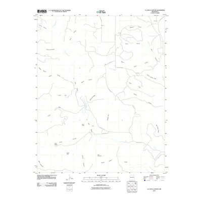
2010 Map of La Cinta Canyon
USGS Topo · Published 2010About this map
La Cinta Creek winds through this corner of San Miguel County, carving a complex network of drainages such as Cañon Toro and Flatiron Canyon. The landscape is defined by its topographic extremes, from the heights of Kicking Foot Mesa and Red Tongue Mesa to the distinct profiles of Deer Mountain and Turkey Head. Isolated settlements and ranching outposts like Laumbach, Porter, and Prichard are connected by a web of rural routes, including Launbach Rd and County Road D. Local heritage is anchored at the Kelly Cemetery, which sits near the junction of several canyons. The map preserves the specific locations of water sources essential to this arid environment, most notably the Wright Springs Windmill and the drainage at Cañada Bonita.
Find a feature on this map
43 named features on this map. Tap any name to fly to it.
Don’t see what you’re looking for? This feature index may not catch every label — zoom into the map to look around manually.
Map Details
Editions of this 2010 La Cinta Canyon Map
This is the sole edition of this map. No revisions or reprints were ever made.
Other maps of this area

1954 · Santa Fe
USGS Topo · 1:250,000

1958 · Santa Fe
USGS Topo · 1:250,000

1971 · Beaver Canyon
USGS Topo · 1:24,000

1971 · Canon Encierro
USGS Topo · 1:24,000

1972 · Arroyo Alamocito
USGS Topo · 1:24,000

1972 · Montoya Point
USGS Topo · 1:24,000

1972 · Waggoner Ranch
USGS Topo · 1:24,000
1974 · Roy
USGS Topo · 1:24,000
1974 · Kansas Valley Lake
USGS Topo · 1:24,000
1974 · Solano
USGS Topo · 1:24,000