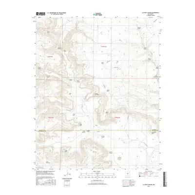
2017 Map of La Cinta Canyon
USGS Topo · Published 2017About this map
La Cinta Canyon dominates this landscape along the boundary of San Miguel and Harding Counties, where the waters of La Cinta Cr have carved a complex network of drainage systems. The map captures a high desert terrain defined by prominent mesas and points, including Kicking Foot Mesa and the sharp profile of Apache Point. A few traces of human presence are scattered across the mesas and canyon floors, most notably the Kelly Cem near Cañon Vigas. The naming conventions throughout the area, such as Cañon Toro, Cañon Gato, and Cañon Calaveras, reflect the region's cultural heritage. Ranch roads like Guest Ranch Ln and Launbach Rd provide the primary access to these remote draws and points like Gato Point.
Find a feature on this map
47 named features on this map. Tap any name to fly to it.
Don’t see what you’re looking for? This feature index may not catch every label — zoom into the map to look around manually.
Map Details
Editions of this 2017 La Cinta Canyon Map
This is the sole edition of this map. No revisions or reprints were ever made.
Other maps of this area

1954 · Santa Fe
USGS Topo · 1:250,000

1958 · Santa Fe
USGS Topo · 1:250,000

1971 · Beaver Canyon
USGS Topo · 1:24,000

1971 · Canon Encierro
USGS Topo · 1:24,000

1972 · Arroyo Alamocito
USGS Topo · 1:24,000

1972 · Montoya Point
USGS Topo · 1:24,000

1972 · Waggoner Ranch
USGS Topo · 1:24,000
1974 · Roy
USGS Topo · 1:24,000
1974 · Kansas Valley Lake
USGS Topo · 1:24,000
1974 · Solano
USGS Topo · 1:24,000