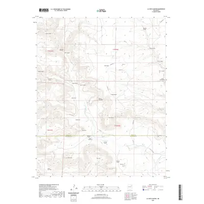
2020 Map of La Cinta Canyon
USGS Topo · Published 2020About this map
La Cinta Canyon dominates this high-plains landscape where the La Cinta Cr carves through the transition between Harding Co and San Miguel Co. The terrain is defined by a series of sharp mesas and named escarpments, including Kicking Foot Mesa, Red-Tongue Mesa, and distinctive landmarks like Turkey Head and Apache Point. The presence of Kelly Cem near Cañon Vigas provides a localized point of interest for genealogists tracking family history in this corner of New Mexico.
Find a feature on this map
48 named features on this map. Tap any name to fly to it.
Don’t see what you’re looking for? This feature index may not catch every label — zoom into the map to look around manually.
Map Details
Editions of this 2020 La Cinta Canyon Map
This is the sole edition of this map. No revisions or reprints were ever made.
Other maps of this area

1954 · Santa Fe
USGS Topo · 1:250,000

1958 · Santa Fe
USGS Topo · 1:250,000

1971 · Beaver Canyon
USGS Topo · 1:24,000

1971 · Canon Encierro
USGS Topo · 1:24,000

1972 · Arroyo Alamocito
USGS Topo · 1:24,000

1972 · Montoya Point
USGS Topo · 1:24,000

1972 · Waggoner Ranch
USGS Topo · 1:24,000
1974 · Roy
USGS Topo · 1:24,000
1974 · Kansas Valley Lake
USGS Topo · 1:24,000
1974 · Solano
USGS Topo · 1:24,000