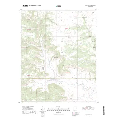
2023 Map of La Cinta Canyon
USGS Topo · Published 2023About this map
La Cinta Creek and Burro Creek define the drainage patterns of this high-plateau landscape, where the border of Harding and San Miguel counties meets. The terrain is marked by dramatic escarpments and named promontories such as Kicking Foot Mesa, Red Tongue Mesa, and the distinctive Turkey Head formation. For those researching local family history, the presence of the Kelly Cem near Cañon Vigas and the designation of School Section Draw provide specific points of interest on an otherwise sparsely settled landscape. A network of rural routes like Launbach Rd and Guest Ranch Ln navigate the complex system of canyons, including Hells Canyon and Archuleta Canyon, which dominate the western half of the map.
Find a feature on this map
47 named features on this map. Tap any name to fly to it.
Don’t see what you’re looking for? This feature index may not catch every label — zoom into the map to look around manually.
Map Details
Editions of this 2023 La Cinta Canyon Map
This is the sole edition of this map. No revisions or reprints were ever made.
Other maps of this area

1954 · Santa Fe
USGS Topo · 1:250,000

1958 · Santa Fe
USGS Topo · 1:250,000

1971 · Beaver Canyon
USGS Topo · 1:24,000

1971 · Canon Encierro
USGS Topo · 1:24,000

1972 · Arroyo Alamocito
USGS Topo · 1:24,000

1972 · Montoya Point
USGS Topo · 1:24,000

1972 · Waggoner Ranch
USGS Topo · 1:24,000
1974 · Roy
USGS Topo · 1:24,000
1974 · Kansas Valley Lake
USGS Topo · 1:24,000
1974 · Solano
USGS Topo · 1:24,000