
1943 Map of La Jolla
USGS Topo · Published 1943About this map
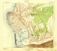
Mission Bay and its surrounding coastal settlements appear in a state of mid-century development, just as the region transitioned through the early 1940s. The coastline is defined by prominent landmarks like Point La Jolla and the Crystal Pier at Pacific Beach, while the Scripps Institute of Oceanography sits north of The Cove. Inland, the landscape of the City of San Diego is etched by deep canyons such as Rose Canyon and San Clemente Canyon, which directed early transportation routes like the Atchison Topeka and Santa Fe railroad and the Coast Highway. The map reveals established institutional sites, including the Brown Military Academy and the Junipero Serra Museum Presidio Park overlooking the Mission Valley, highlighting the civic and educational infrastructure of the era. This survey captures a specific period before the massive postwar transformations altered the marshlands of the bay into modern recreational basins.
Find a feature on this map
63 named features on this map. Tap any name to fly to it.
Don’t see what you’re looking for? This feature index may not catch every label — zoom into the map to look around manually.
Map Details
Editions of this 1943 La Jolla Map
2 editions found
Other maps of this area

1903 · La Jolla
USGS Topo · 1:62,500

1904 · San Diego
USGS Topo · 1:62,500

1904 · Southern California Sheet No. 2
USGS Topo · 1:250,000

1930 · La Jolla
USGS Topo · 1:62,500

1930 · San Diego
USGS Topo · 1:62,500

1942 · Poway Valley
USGS Topo · 1:31,680
1942 · La Mesa
USGS Topo · 1:31,680

1942 · Point Loma
USGS Topo · 1:31,680
1943 · Del Mar
USGS Topo · 1:31,680
1944 · National City
USGS Topo · 1:31,680