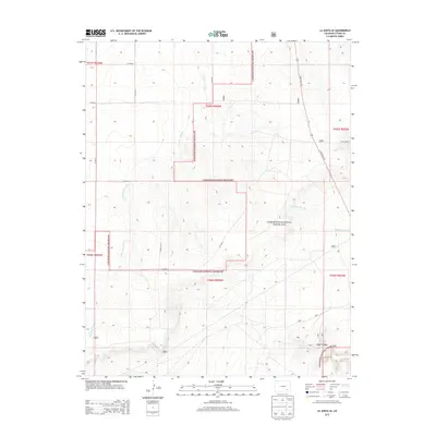
2013 Map of La Junta SE
USGS Topo · Published 2013About this map
Comanche National Grassland dominates this corner of Otero County, where the high plains break into a network of dry watercourses. The landscape is defined by the sharp descent into Vogel Canyon in the southeast, a significant geographic feature that historically provided shelter and water in an otherwise arid environment. Early 21st-century cattle ranching is evidenced by the presence of the Carrica Ranch, located near the intersection of State Hwy 109 and the eastern boundary. The intricate drainage patterns of Anderson Arroyo, McMahon Arroyo, and Salt Arroyo illustrate the erosional forces that have carved the grassland plateau. This map reveals a sparse but functional grid of rural roads, including CO Road S and CO Road L, which provide the primary access to these remote canyonlands and range areas.
Find a feature on this map
22 named features on this map. Tap any name to fly to it.
Don’t see what you’re looking for? This feature index may not catch every label — zoom into the map to look around manually.
Map Details
Editions of this 2013 La Junta SE Map
This is the sole edition of this map. No revisions or reprints were ever made.
Other maps of this area

1891 · Higbee
USGS Topo · 1:125,000

1891 · Timpas
USGS Topo · 1:125,000

1893 · Higbee
USGS Topo · 1:125,000

1894 · Timpas
USGS Topo · 1:125,000

1955 · La Junta
USGS Topo · 1:250,000

1958 · La Junta
USGS Topo · 1:250,000

1965 · La Junta SW
USGS Topo · 1:24,000

1966 · La Junta SE
USGS Topo · 1:24,000
1966 · Hawley
USGS Topo · 1:24,000
1966 · La Junta
USGS Topo · 1:24,000