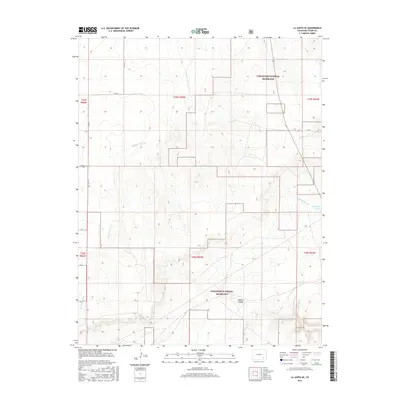
2016 Map of La Junta SE
USGS Topo · Published 2016About this map
Comanche National Grassland dominates this high plains landscape south of the Arkansas River valley, where the terrain is defined by a network of drainage systems cutting through the arid plateau. The presence of Vogel Canyon highlights the topographic variation of the area, providing a distinct landform amid the surrounding rangeland. This survey captures the remote character of Otero County in the mid-2010s, illustrating how the land is partitioned into vast townships such as t25s r55w and t26s r55w.
Find a feature on this map
16 named features on this map. Tap any name to fly to it.
Don’t see what you’re looking for? This feature index may not catch every label — zoom into the map to look around manually.
Map Details
Editions of this 2016 La Junta SE Map
This is the sole edition of this map. No revisions or reprints were ever made.
Other maps of this area

1891 · Higbee
USGS Topo · 1:125,000

1891 · Timpas
USGS Topo · 1:125,000

1893 · Higbee
USGS Topo · 1:125,000

1894 · Timpas
USGS Topo · 1:125,000

1955 · La Junta
USGS Topo · 1:250,000

1958 · La Junta
USGS Topo · 1:250,000

1965 · La Junta SW
USGS Topo · 1:24,000

1966 · La Junta SE
USGS Topo · 1:24,000
1966 · Hawley
USGS Topo · 1:24,000
1966 · La Junta
USGS Topo · 1:24,000