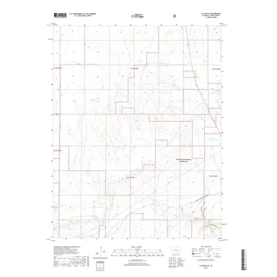
2019 Map of La Junta SE
USGS Topo · Published 2019About this map
Comanche National Grassland encompasses much of this high plains landscape, where the intersection of natural drainage systems and historic transportation routes defines the terrain. The northern portion of the map is dominated by the winding paths of Anderson Arroyo, Salt Arroyo, and McMahon Arroyo, which carve subtle relief into the expansive Prairie. An interpretive highlight is the presence of the Barlow-Sanderson Wagon Road in the southeast, a remnant of the historic stagecoach line that once connected the southern plains. This historic corridor runs adjacent to distinctive geological features like the Mesa and Overlook near Vogel Canyon, areas where the topography breaks into significant rock formations. The grid of county roads, including Co RD 25 and Co RD N, follows the township and range lines, illustrating the systematic rural subdivision typical of Otero County.
Find a feature on this map
21 named features on this map. Tap any name to fly to it.
Don’t see what you’re looking for? This feature index may not catch every label — zoom into the map to look around manually.
Map Details
Editions of this 2019 La Junta SE Map
This is the sole edition of this map. No revisions or reprints were ever made.
Other maps of this area

1891 · Higbee
USGS Topo · 1:125,000

1891 · Timpas
USGS Topo · 1:125,000

1893 · Higbee
USGS Topo · 1:125,000

1894 · Timpas
USGS Topo · 1:125,000

1955 · La Junta
USGS Topo · 1:250,000

1958 · La Junta
USGS Topo · 1:250,000

1965 · La Junta SW
USGS Topo · 1:24,000

1966 · La Junta SE
USGS Topo · 1:24,000
1966 · Hawley
USGS Topo · 1:24,000
1966 · La Junta
USGS Topo · 1:24,000