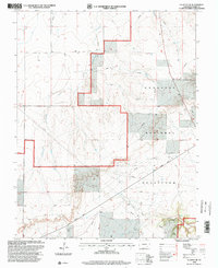
1996 Map of La Junta SE
USGS Topo · Published 2000About this map
Comanche National Grassland defines this high-plains landscape, where the conservation efforts of the USDA Forest Service are layered over a grid of ranching roads and water improvements. This late twentieth-century revision reveals a terrain deeply etched by drainage systems like Anderson Arroyo and the unnamed Arroyo to the north, which flow toward the deeper incisions of the canyon country. The map illustrates a landscape of utility and resource management, marked by numerous Pipeline corridors and isolated water sources such as a Spring and Well that sustained local agricultural operations. In the south, the dramatic topography of David Canyon and Vogel Canyon breaks the plateau, providing a detailed look at the geographic features that have historically influenced movement and land use in this part of Otero County.
Find a feature on this map
9 named features on this map. Tap any name to fly to it.
Don’t see what you’re looking for? This feature index may not catch every label — zoom into the map to look around manually.
Map Details
Editions of this 1996 La Junta SE Map
This is the sole edition of this map. No revisions or reprints were ever made.
Other maps of this area

1891 · Higbee
USGS Topo · 1:125,000

1891 · Timpas
USGS Topo · 1:125,000

1893 · Higbee
USGS Topo · 1:125,000

1894 · Timpas
USGS Topo · 1:125,000

1955 · La Junta
USGS Topo · 1:250,000

1958 · La Junta
USGS Topo · 1:250,000

1965 · La Junta SW
USGS Topo · 1:24,000

1966 · La Junta SE
USGS Topo · 1:24,000
1966 · Hawley
USGS Topo · 1:24,000
1966 · La Junta
USGS Topo · 1:24,000