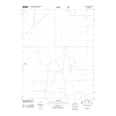
2011 Map of La Junta SW
USGS Topo · Published 2011About this map
Crooked Arroyo and its tributaries define this corner of the Colorado high plains in the early 21st century. The map provides a detailed look at the drainage systems southeast of the Arkansas River valley, including Benton Arroyo and Timpas Creek. A prominent local landmark, the Browning and Reese Number 1 Dam, stands as a testament to water management efforts in this arid landscape. To the southeast, the Shale Hills rise above the surrounding basin, offering a distinct geological boundary. The area is characterized by a precise grid of rural thoroughfares, such as County Road N and County Road 21, which structure the ranching and agricultural land. This survey is particularly useful for understanding the modern hydraulic and transportation infrastructure in Otero County.
Find a feature on this map
18 named features on this map. Tap any name to fly to it.
Don’t see what you’re looking for? This feature index may not catch every label — zoom into the map to look around manually.
Map Details
Editions of this 2011 La Junta SW Map
This is the sole edition of this map. No revisions or reprints were ever made.
Other maps of this area

1891 · Timpas
USGS Topo · 1:125,000

1894 · Timpas
USGS Topo · 1:125,000

1955 · La Junta
USGS Topo · 1:250,000

1958 · La Junta
USGS Topo · 1:250,000

1965 · La Junta SW
USGS Topo · 1:24,000

1966 · La Junta SE
USGS Topo · 1:24,000
1966 · Hawley
USGS Topo · 1:24,000
1966 · La Junta
USGS Topo · 1:24,000

1968 · La Junta
USGS Topo · 1:250,000
1972 · Timpas NE
USGS Topo · 1:24,000