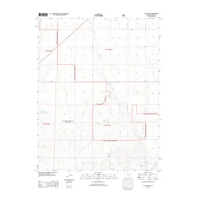
2013 Map of La Junta SW
USGS Topo · Published 2013About this map
Comanche National Grassland dominates this section of Otero County, where a system of arroyos and canyons defines the high plains drainage south of the Arkansas River. The landscape is carved by seasonal watercourses including Timpas Cr, Crooked Arroyo, and Benton Arroyo, which weave through the townships of t025s r057w and t026s r056w. Human engineering is limited to the scattered rural road network and the Browning and Reese Number 1 Reservoir, a vital water management feature in this arid environment. Near the southern edge of the survey, the Shale Hills rise above the confluence of the W Br Crooked Arroyo, illustrating the transition from flat prairie to the broken, dissected terrain typical of the Colorado plains. This 2013 record documents the area just prior to modern land-use shifts, focusing on the public lands and primary transit corridors like Co-71.
Find a feature on this map
22 named features on this map. Tap any name to fly to it.
Don’t see what you’re looking for? This feature index may not catch every label — zoom into the map to look around manually.
Map Details
Editions of this 2013 La Junta SW Map
This is the sole edition of this map. No revisions or reprints were ever made.
Other maps of this area

1891 · Timpas
USGS Topo · 1:125,000

1894 · Timpas
USGS Topo · 1:125,000

1955 · La Junta
USGS Topo · 1:250,000

1958 · La Junta
USGS Topo · 1:250,000

1965 · La Junta SW
USGS Topo · 1:24,000

1966 · La Junta SE
USGS Topo · 1:24,000
1966 · Hawley
USGS Topo · 1:24,000
1966 · La Junta
USGS Topo · 1:24,000

1968 · La Junta
USGS Topo · 1:250,000
1972 · Timpas NE
USGS Topo · 1:24,000