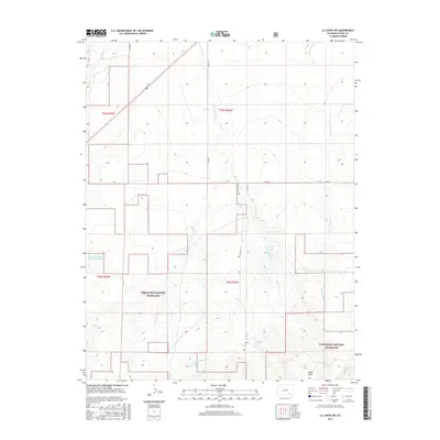
2016 Map of La Junta SW
USGS Topo · Published 2016About this map
Comanche National Grassland dominates the southern landscape of this Otero County quadrangle, where the High Plains terrain is etched by a series of intermittent drainage systems. The water network is defined by north-flowing arroyos, including Benton Arroyo, Crooked Arroyo, and the W Br Crooked Arroyo, which channel seasonal runoff toward the Arkansas River valley to the north. In the northwest corner, Timpas Cr cuts across the township line, while the Browning and Reese Reservoir Number 1 represents a significant modification of the natural hydrology for agricultural use. The presence of Shale Hills in the southeast suggests the underlying geology that shapes this semi-arid environment. The rectangular survey system is clearly visible, with section lines and rural routes like Co RD 21 and Co RD N providing the primary structure for movement across this expanse of public and private land.
Find a feature on this map
16 named features on this map. Tap any name to fly to it.
Don’t see what you’re looking for? This feature index may not catch every label — zoom into the map to look around manually.
Map Details
Editions of this 2016 La Junta SW Map
This is the sole edition of this map. No revisions or reprints were ever made.
Other maps of this area

1891 · Timpas
USGS Topo · 1:125,000

1894 · Timpas
USGS Topo · 1:125,000

1955 · La Junta
USGS Topo · 1:250,000

1958 · La Junta
USGS Topo · 1:250,000

1965 · La Junta SW
USGS Topo · 1:24,000

1966 · La Junta SE
USGS Topo · 1:24,000
1966 · Hawley
USGS Topo · 1:24,000
1966 · La Junta
USGS Topo · 1:24,000

1968 · La Junta
USGS Topo · 1:250,000
1972 · Timpas NE
USGS Topo · 1:24,000