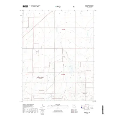
2019 Map of La Junta SW
USGS Topo · Published 2019About this map
The Santa Fe Nat Hist Trail cuts across the northwest corner of this Otero County landscape, marking a legacy of western transit through the shortgrass prairie. This 2019 survey reveals a sparsely settled region dominated by the Comanche National Grassland, where complex drainage systems like Crooked Arroyo, Benton Arroyo, and Timpas Cr carve through the high plains. In the southern portion of the quadrangle, the Shale Hills rise near the W Br Crooked Arroyo, providing topographical contrast to the surrounding section lines and range boundaries. A network of county roads, including Co Rd 19 and Co Rd 21, follows the rectilinear Public Land Survey System, illustrating how modern administrative boundaries have been superimposed over the natural watercourses and historic wagon routes of the Colorado high desert.
Find a feature on this map
17 named features on this map. Tap any name to fly to it.
Don’t see what you’re looking for? This feature index may not catch every label — zoom into the map to look around manually.
Map Details
Editions of this 2019 La Junta SW Map
This is the sole edition of this map. No revisions or reprints were ever made.
Other maps of this area

1891 · Timpas
USGS Topo · 1:125,000

1894 · Timpas
USGS Topo · 1:125,000

1955 · La Junta
USGS Topo · 1:250,000

1958 · La Junta
USGS Topo · 1:250,000

1965 · La Junta SW
USGS Topo · 1:24,000

1966 · La Junta SE
USGS Topo · 1:24,000
1966 · Hawley
USGS Topo · 1:24,000
1966 · La Junta
USGS Topo · 1:24,000

1968 · La Junta
USGS Topo · 1:250,000
1972 · Timpas NE
USGS Topo · 1:24,000