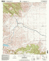
1995 Map of La Liebre Ranch
USGS Topo · Published 1999About this map
The San Andreas Fault Zone cuts dramatically across the southern portion of this landscape, marking a clear geological boundary near Bald Mountain. To the north, the terrain is dominated by the complex water infrastructure of the California Aqueduct, including the Oso Pumping Plant, the Tehachapi Afterbay, and an intricate system of flumes and siphons that channel water through the foothills. The La Liebre Ranch occupies a central position among the deep ravines of Horse Camp Canyon and Cow Canyon, while Quail Lake sits at the southwestern edge alongside the Quail Lake Sky Park. This map reveals a high-desert environment defined by the intersection of massive public works and the natural tectonic landscape of the Tehachapi Mountains, with numerous springs dotting the canyons that feed into the larger valley.
Find a feature on this map
29 named features on this map. Tap any name to fly to it.
Don’t see what you’re looking for? This feature index may not catch every label — zoom into the map to look around manually.
Map Details
Editions of this 1995 La Liebre Ranch Map
This is the sole edition of this map. No revisions or reprints were ever made.
Other maps of this area

1903 · Tejon
USGS Topo · 1:125,000

1932 · Neenach
USGS Topo · 1:24,000

1933 · Quail
USGS Topo · 1:24,000

1938 · Liebre
USGS Topo · 1:24,000

1938 · Quail
USGS Topo · 1:24,000

1943 · Neenach
USGS Topo · 1:62,500
1945 · Pastoria Creek
USGS Topo · 1:31,680
1945 · Lebec
USGS Topo · 1:31,680
1945 · Black Mtn
USGS Topo · 1:31,680

1949 · Los Angeles
USGS Topo · 1:250,000