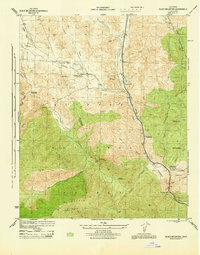
1945 Map of Black Mtn
USGS Topo · Published 1945About this map
Lane Ranch and the Caswells settlement mark the developed fringe of the Los Angeles National Forest at the end of World War II. The landscape is defined by the steep drainage basins of Piru Creek and Canada de los Alamos, where narrow canyons dictated the path of early automotive infrastructure. The presence of the Southern Calif Gas Co Maint Sta No 5 and multiple Highway Maint Sta locations illustrates the vital role this corridor played in regional utility and transport logistics. Higher elevations are dotted with administrative outposts such as the Piru Guard Stat and Smith Fork Guard Sta, while the Bayley Homestead provides a glimpse into the late-stage ranching and homesteading history of the Los Angeles-Ventura county line. Local landmarks like Pyramid Rock and Ridge Tavern anchor this high-altitude transition between the valley and the peaks of Black Mtn.
Find a feature on this map
42 named features on this map. Tap any name to fly to it.
Don’t see what you’re looking for? This feature index may not catch every label — zoom into the map to look around manually.
Map Details
Editions of this 1945 Black Mtn Map
This is the sole edition of this map. No revisions or reprints were ever made.
Other maps of this area

1903 · Tejon
USGS Topo · 1:125,000

1932 · Beartrap Canyon
USGS Topo · 1:24,000

1933 · Quail
USGS Topo · 1:24,000

1933 · Gorman
USGS Topo · 1:24,000

1938 · Beartrap Canyon
USGS Topo · 1:24,000

1938 · Gorman
USGS Topo · 1:24,000

1938 · Black Mountain
USGS Topo · 1:24,000

1938 · Quail
USGS Topo · 1:24,000

1942 · Frazier Mountain
USGS Topo · 1:24,000

1943 · Neenach
USGS Topo · 1:62,500