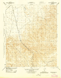
1945 Map of Pastoria Creek
USGS Topo · Published 1945About this map
The San Joaquin Valley meets the rising terrain of the Tehachapi foothills in this 1945 survey, where the landscape is defined by the critical movement of water and power. Pastoria Creek and Tunis Creek cut through steep canyons, feeding toward the valley floor where a Reservoir and a system including a Ditch manage the region's limited water resources. High-altitude points such as Knapp and Huey provide survey benchmarks overlooking the complex topography. Infrastructure development is prominent along the western edge, marked by the S C E Co Transmission Line and an additional Transmission Line, reflecting the mid-century expansion of the electrical grid into Southern California. The proximity of Highway No. 99 underscores this area's role as a vital transportation and utility corridor connecting the Central Valley with the southern part of the state.
Find a feature on this map
11 named features on this map. Tap any name to fly to it.
Don’t see what you’re looking for? This feature index may not catch every label — zoom into the map to look around manually.
Map Details
Editions of this 1945 Pastoria Creek Map
This is the sole edition of this map. No revisions or reprints were ever made.
Other maps of this area

1903 · Tejon
USGS Topo · 1:125,000

1914 · Caliente
USGS Topo · 1:125,000

1931 · West of Tejon Hills
USGS Topo · 1:31,680

1931 · Tejon Hills
USGS Topo · 1:31,680

1933 · Tejon Hills
USGS Topo · 1:31,680
1934 · West of Tejon Hills
USGS Topo · 1:31,680

1942 · Tecuya Creek
USGS Topo · 1:24,000

1942 · Frazier Mountain
USGS Topo · 1:24,000

1943 · Cummings Mountain
USGS Topo · 1:62,500

1943 · Neenach
USGS Topo · 1:62,500