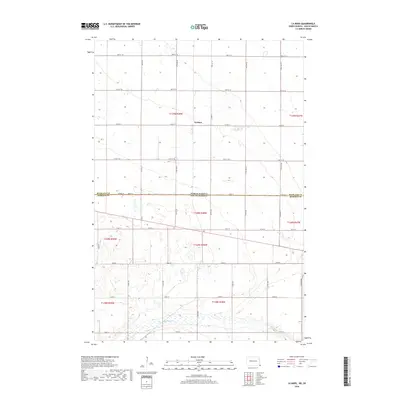
2018 Map of La Mars
USGS Topo · Published 2018About this map
The settlement of La Mars serves as the central point for this 2018 survey, situated at a cross-border juncture where the High Plains landscape meets the jurisdictional divide of North Dakota and South Dakota. This map captures a strictly gridded prairie environment, defined by its section lines and agricultural road network, including arterial routes like Co Rd 22 and Co Rd 81. To the north lies the border of Richland County, while the southern portion reveals the drainage patterns of Big Slough. The landscape is a study in early 21st-century rural organization, where the township and range system (T129N, T128N) dictates the placement of farmsteads and access roads across the fertile plains of Roberts County.
Find a feature on this map
34 named features on this map. Tap any name to fly to it.
Don’t see what you’re looking for? This feature index may not catch every label — zoom into the map to look around manually.
Map Details
Editions of this 2018 La Mars Map
This is the sole edition of this map. No revisions or reprints were ever made.
Other maps of this area

1904 · Wahpeton
USGS Topo · 1:125,000

1915 · White Rock
USGS Topo · 1:62,500

1917 · New Effington
USGS Topo · 1:62,500

1918 · White Rock
USGS Topo · 1:62,500

1953 · Milbank
USGS Topo · 1:250,000

1953 · Fargo
USGS Topo · 1:250,000

1956 · Fargo
USGS Topo · 1:250,000

1958 · Milbank
USGS Topo · 1:250,000

1964 · Hankinson SE
USGS Topo · 1:24,000
1972 · La Mars
USGS Topo · 1:24,000
Featured Places
- Lake Traverse District, SD
- Fairmount Township, ND
- LaMars Township, ND
- White Rock Hutterite Colony, SD
- La Mars, ND