
1963 Map of La Pine
USGS Topo · Published 1964About this map
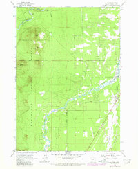
The Little Deschutes River meanders through this Central Oregon landscape, providing the primary hydrological corridor for the growing settlement at La Pine. By the early 1960s, the community layout is clearly defined along the north-south axis of Huntington Road and Pierce Road, while the surrounding terrain is dominated by the volcanic forms of Pringle Butte, Cruiser Butte, and Wampus Butte.
Find a feature on this map
25 named features on this map. Tap any name to fly to it.
Don’t see what you’re looking for? This feature index may not catch every label — zoom into the map to look around manually.
Map Details
Editions of this 1963 La Pine Map
2 editions found
Other maps of this area

1930 · Maiden Peak
USGS Topo · 1:125,000

1931 · Newberry Crater
USGS Topo · 1:125,000

1934 · Maiden Peak
USGS Topo · 1:125,000

1935 · Newberry Crater
USGS Topo · 1:125,000

1955 · Crescent
USGS Topo · 1:250,000

1957 · Crescent
USGS Topo · 1:250,000

1958 · Crescent
USGS Topo · 1:250,000

1963 · Round Mountain
USGS Topo · 1:24,000
1963 · Anns Butte
USGS Topo · 1:24,000

1963 · Masten Butte
USGS Topo · 1:24,000