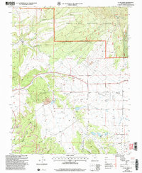
2001 Map of La Sal West
USGS Topo · Published 2004About this map
The high desert and mountain interface of Manti-La Sal National Forest dominates this topography, where the plateau is deeply incised by drainages like Cottonwood Canyon and Joe Wilson Canyon. The landscape shows a clear divide between the forested elevations of the Moab Ranger District and the industrial activity occurring on the lower flats. Mining infrastructure is prominent, with the Lisbon Mine and several shafts, including the Hecla Shaft and an Open Pit Mine, indicating the region's mineral dependency at the turn of the 21st century. The small community of La Sal sits at a crossroads, accompanied by a Cem and a Mobile Home Park. Notable geological landmarks such as Wilson Arch and Rattlesnake Rock provide reference points for those studying the area's distinct natural formations and historic land use patterns.
Find a feature on this map
27 named features on this map. Tap any name to fly to it.
Don’t see what you’re looking for? This feature index may not catch every label — zoom into the map to look around manually.
Map Details
Editions of this 2001 La Sal West Map
This is the sole edition of this map. No revisions or reprints were ever made.
Other maps of this area

1885 · La Sal
USGS Topo · 1:250,000

1954 · Mt Peale 3 NW
USGS Topo · 1:24,000

1954 · Mt Peale 4 NW
USGS Topo · 1:24,000

1954 · Mt Peale 3 NE
USGS Topo · 1:24,000

1954 · Mt Peale 1 SW
USGS Topo · 1:24,000

1954 · Mt Peale 1 NW
USGS Topo · 1:24,000

1954 · Mt Peale 2 SW
USGS Topo · 1:24,000

1954 · Mt Peale 2 NW
USGS Topo · 1:24,000

1954 · Mt Peale 2 SE
USGS Topo · 1:24,000

1954 · Mt Peale 2 NE
USGS Topo · 1:24,000