
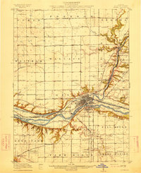
1911 Map of La Salle
USGS Topo · Published 1911About this map
The Illinois River corridor serves as the industrial and transit heart of this 1911 survey, where the concentrated development of La Salle, Peru, and Spring Valley reflects the region's intense coal mining and manufacturing era. The landscape is a dense network of competing rail lines, including the Chicago Rock Island and Pacific RR and the Illinois Valley Electric RR, which stitch together mining towns like Ladd and Cherry. A key historical feature is the Illinois and Michigan Canal, visible running parallel to the river and passing the distinctive Split Rock formation.
Find a feature on this map
87 named features on this map. Tap any name to fly to it.
Don’t see what you’re looking for? This feature index may not catch every label — zoom into the map to look around manually.
Map Details
Editions of this 1911 La Salle Map
This is the sole edition of this map. No revisions or reprints were ever made.
Other maps of this area

1892 · Ottawa
USGS Topo · 1:62,500

1893 · Lacon
USGS Topo · 1:62,500

1893 · Hennepin
USGS Topo · 1:62,500

1893 · Lasalle
USGS Topo · 1:62,500

1909 · Hennepin
USGS Topo · 1:62,500

1911 · Hennepin
USGS Topo · 1:62,500

1913 · La Salle
USGS Topo · 1:62,500
1915 · Ottawa
USGS Topo · 1:62,500

1925 · Streator
USGS Topo · 1:62,500
1927 · Streator
USGS Topo · 1:62,500