
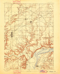
1893 Map of Hennepin
USGS Topo · Published 1893About this map
Princeton serves as the primary hub of this late nineteenth-century landscape, where the prairie grid of Bureau County meets the complex hydrology of the Illinois River valley. The area is defined by the convergence of major transportation lines, including the Chicago Rock Island and Pacific Railway and the Chicago Burlington and Quincy Railroad, which shaped the growth of towns like Bureau Junction and Malden. To the south, the Illinois River and Lake Depue dominate the terrain, surrounded by a network of drainage including Big Bureau Creek and Allforks Creek. The map documents numerous smaller settlements such as Hollowayville, Seatonville, and Limerick during a period of significant agricultural and rail expansion. The detailed topography illustrates the stark contrast between the flat upland townships of Dover and Berlin and the deeply eroded bluffs overlooking the river bottoms near Hennepin.
Find a feature on this map
35 named features on this map. Tap any name to fly to it.
Don’t see what you’re looking for? This feature index may not catch every label — zoom into the map to look around manually.
Map Details
Editions of this 1893 Hennepin Map
2 editions found
Other maps of this area

1893 · Lacon
USGS Topo · 1:62,500

1893 · Lasalle
USGS Topo · 1:62,500

1909 · Hennepin
USGS Topo · 1:62,500

1911 · La Salle
USGS Topo · 1:62,500

1911 · Hennepin
USGS Topo · 1:62,500

1913 · La Salle
USGS Topo · 1:62,500

1921 · Buda
USGS Topo · 1:62,500

1923 · Buda
USGS Topo · 1:62,500

1933 · Lacon
USGS Topo · 1:62,500

1933 · Camp Grove
USGS Topo · 1:48,000