
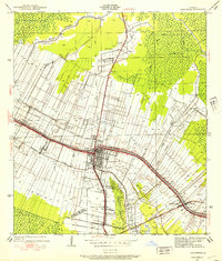
1932 Map of Lac Des Allemands NW
USGS Topo · Published 1932About this map
Vacherie sits at the heart of this 1932 topographical study, where the alluvial lands of the Mississippi River meet the cypress swamps of southeastern Louisiana. The landscape is defined by the transition from organized agricultural strips along the river to the dense, winding waterways that feed into Lac Des Allemands. Transportation and industry in the early 1930s are represented by the Texas and Pacific railroad line and the Dredge Boat Canal, while local community life is anchored by facilities such as Vacherie Sch, Armant Sch, and Marse Sch.
Find a feature on this map
26 named features on this map. Tap any name to fly to it.
Don’t see what you’re looking for? This feature index may not catch every label — zoom into the map to look around manually.
Map Details
Editions of this 1932 Lac Des Allemands NW Map
This is the sole edition of this map. No revisions or reprints were ever made.
Other maps of this area

1892 · Lac Des Allemands
USGS Topo · 1:62,500

1892 · Mount Airy
USGS Topo · 1:62,500

1892 · Donaldsonville
USGS Topo · 1:62,500

1892 · Thibodaux
USGS Topo · 1:62,500

1932 · Lac Des Allemands SE
USGS Topo · 1:31,680

1932 · Lac Des Allemands SW
USGS Topo · 1:31,680

1932 · Thibodaux NE
USGS Topo · 1:31,680

1932 · Lac Des Allemands NE
USGS Topo · 1:31,680

1932 · Thibodaux SE
USGS Topo · 1:31,680
1938 · Lafourche
USGS Topo · 1:24,000
Featured Places
- Golden Star Plantation, LA
- North Vacherie, LA
- Southdown Plantation, LA
- Armant, LA
- Webre Steib Plantation, LA