
1946 Map of Lac Du Flambeau
USGS Topo · Published 1946About this map
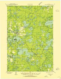
Lac du Flambeau serves as the focal point for this lake-dotted landscape in the mid-1940s, situated at the crossroads of the Chicago and Northwestern railroad and State Hy No 70. The map reveals a highly connected aquatic network, where large bodies of water like Crawling Stone Lake and Pokegama Lake are punctuated by smaller, isolated features such as Reservation Line Lake and Minette Lake. Local life is anchored by the Marlands Sch and the community at Marlands, while the Flambeau Fire Tower provides a critical vantage point over the timberlands. Large portions of the territory are managed as the Chequamegon National Forest and Northern Highland State Forest, illustrating the importance of conservation and forestry in Oneida and Vilas counties during this era. Small settlements like Haverer are also noted, providing essential markers for genealogical research in this Northwoods region.
Find a feature on this map
115 named features on this map. Tap any name to fly to it.
Don’t see what you’re looking for? This feature index may not catch every label — zoom into the map to look around manually.
Map Details
Editions of this 1946 Lac Du Flambeau Map
This is the sole edition of this map. No revisions or reprints were ever made.
Other maps of this area
1938 · Minocqua
USGS Topo · 1:48,000

1938 · Lac Du Flambeau
USGS Topo · 1:48,000

1939 · Trout Lake
USGS Topo · 1:48,000

1939 · Lac Du Flambeau
USGS Topo · 1:48,000

1939 · Mc Cord
USGS Topo · 1:48,000

1939 · Winchester
USGS Topo · 1:48,000

1939 · Cassian
USGS Topo · 1:48,000

1940 · Mercer
USGS Topo · 1:48,000

1941 · Pike Lake
USGS Topo · 1:48,000

1941 · Brantwood
USGS Topo · 1:48,000