
1939 Map of Cassian
USGS Topo · Published 1946About this map
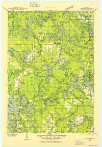
American Legion State Forest dominates the northern reaches of this lake-studded landscape in Oneida County, surveyed just before the 1940s. The map illustrates a region defined by its dense network of glacial lakes, from the large Bearskin Lake and Currie Lake to smaller basins like Fawn L and Lumen L. Three major rail lines facilitate movement through the area, including the Chicago Milwaukee St Paul and Pacific and the Minneapolis St Paul and Sault Ste Marie, which intersect at Heafford Junction.
Find a feature on this map
139 named features on this map. Tap any name to fly to it.
Don’t see what you’re looking for? This feature index may not catch every label — zoom into the map to look around manually.
Map Details
Editions of this 1939 Cassian Map
4 editions found

Other maps of this area

1930 · Robbins
USGS Topo · 1:48,000
1938 · Minocqua
USGS Topo · 1:48,000
1938 · Robbins
USGS Topo · 1:48,000

1938 · Lac Du Flambeau
USGS Topo · 1:48,000

1939 · Lac Du Flambeau
USGS Topo · 1:48,000

1939 · Mc Cord
USGS Topo · 1:48,000

1940 · Parrish
USGS Topo · 1:48,000

1940 · Rhinelander
USGS Topo · 1:48,000

1942 · Cassian
USGS Topo · 1:48,000

1945 · Robbins
USGS Topo · 1:48,000