
1940 Map of Parrish
USGS Topo · Published 1940About this map
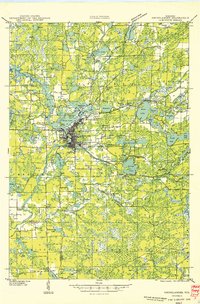
Enterprise township and the small settlement of Enterprise anchor the northern edge of this 1940 field examination, which reveals a transition in the Northwoods landscape. While the northern tier is well-documented with roads and water bodies like Shingle Mill Lake, a significant portion of the sheet remains designated as an Unsurveyed Area, reflecting the ongoing nature of topographic mapping in this part of Wisconsin. The presence of the Chicago and Northwestern railroad line running through the northeast corner highlights the area's historical connection to industrial transport and timber. This advance sheet, compiled from aerial photographs, captures the boundary intersections of Lincoln, Oneida, and Langlade counties during a period when the County Trunk Highway system was still being formalized through the forest and wetlands.
Find a feature on this map
8 named features on this map. Tap any name to fly to it.
Don’t see what you’re looking for? This feature index may not catch every label — zoom into the map to look around manually.
Map Details
Editions of this 1940 Parrish Map
This is the sole edition of this map. No revisions or reprints were ever made.
Other maps of this area

1899 · Wausau
USGS Topo · 1:125,000

1902 · Wausau
USGS Topo · 1:125,000

1939 · Cassian
USGS Topo · 1:48,000

1940 · Monico
USGS Topo · 1:48,000

1940 · Rhinelander
USGS Topo · 1:48,000

1942 · Cassian
USGS Topo · 1:48,000

1942 · Elcho
USGS Topo · 1:48,000
1949 · Rhinelander
USGS Topo · 1:48,000

1950 · Monico
USGS Topo · 1:48,000
1950 · Elcho
USGS Topo · 1:48,000