
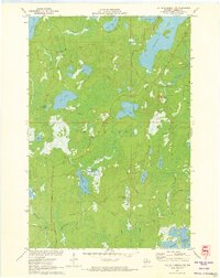
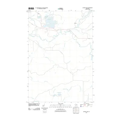
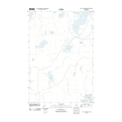
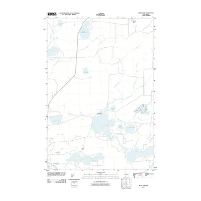
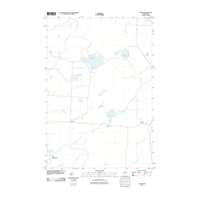
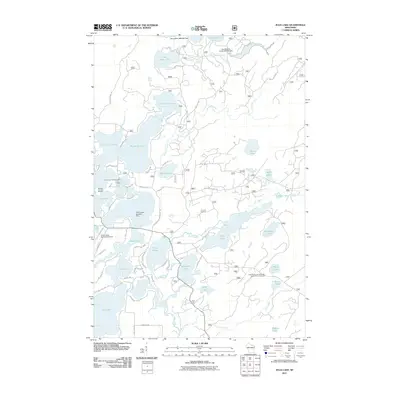
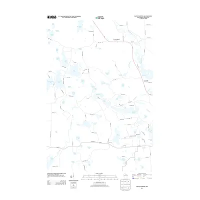
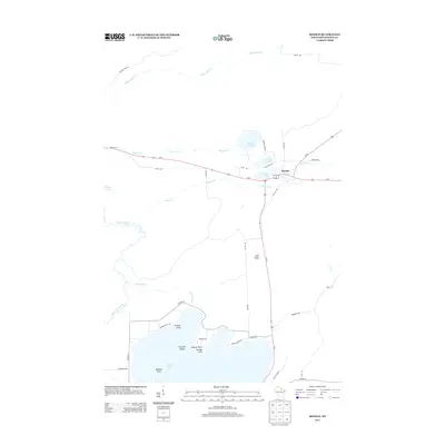
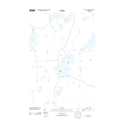
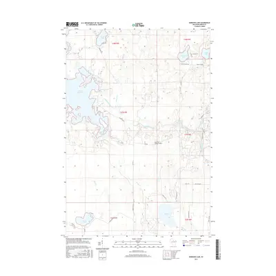
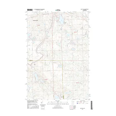
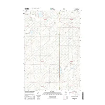
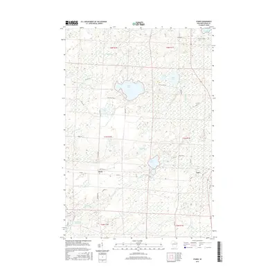
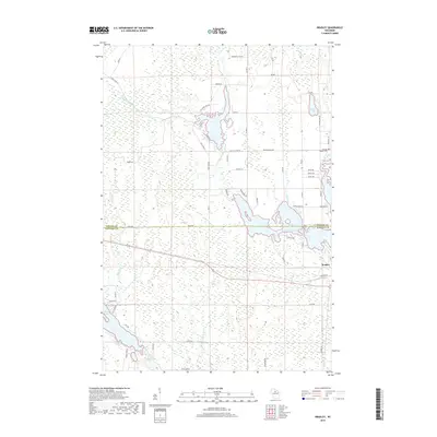
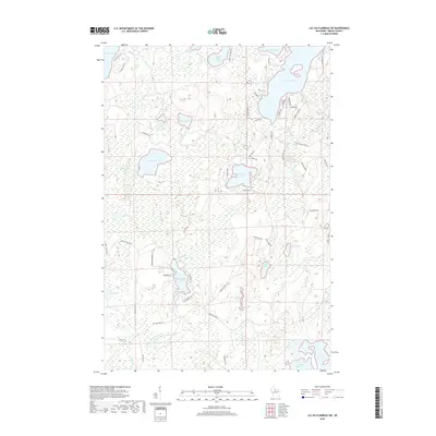
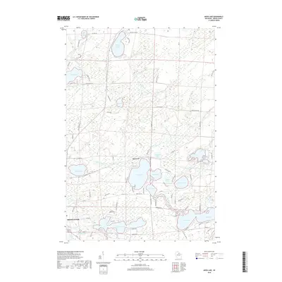
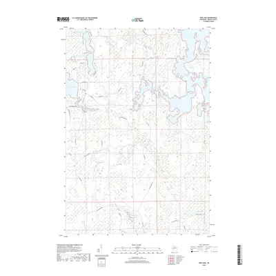
1971 Map of Lac Du Flambeau SW
USGS Topo · Published 1979About this map
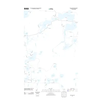
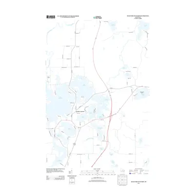
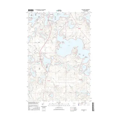
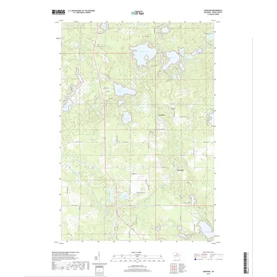
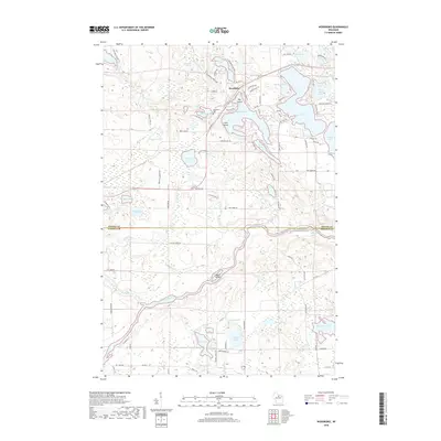
The Cranberry Bog sits as a central feature of this northern Wisconsin landscape, surrounded by a complex network of glacial lakes and wetlands within the town of Minocqua. Water dominates the geography, from the sprawling Squirrel Lake and its outlet at the Squirrel River in the east to the southern expanse of the Willow Reservoir. In the early 1970s, the area maintained a distinctively quiet character, with navigation primarily defined by local routes like Squirrel Lake Road and Manhardt Road. Evidence of fire management and forestry oversight is visible at Squirrel Hill, where the Squirrel Hill Lookout Tower provided a high vantage point over the timberlands and private estates. Smaller, isolated water bodies like Swamsauger Lake and Stone Lake are interspersed with low-lying springs, including the named Camp Fifteen Springs.
Find a feature on this map
35 named features on this map. Tap any name to fly to it.
Don’t see what you’re looking for? This feature index may not catch every label — zoom into the map to look around manually.
Map Details
Editions of this 1971 Lac Du Flambeau SW Map
2 editions found
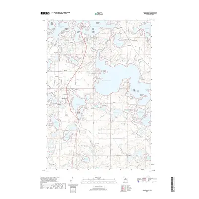
Historical Maps of Minocqua Through Time
141 maps found

1930 Robbins
Oneida County, WI

1938 Lac Du Flambeau
Oneida County, WI

1938 Robbins
Oneida County, WI

1939 Cassian
Oneida County, WI

1939 Lac Du Flambeau
Oneida County, WI

1939 Mc Cord
Oneida County, WI

1940 Monico
Oneida County, WI

1942 Cassian
Oneida County, WI

1945 Robbins
Oneida County, WI

1946 Lac Du Flambeau
Oneida County, WI

1947 Mc Cord
Oneida County, WI

1950 Lac Du Flambeau
Oneida County, WI

1950 Monico
Oneida County, WI

1951 Lac Du Flambeau
Oneida County, WI

1965 Monico NE
Oneida County, WI

1965 Monico
Oneida County, WI

1965 Nashville
Oneida County, WI

1965 Starks
Oneida County, WI

1966 Heafford Junction
Oneida County, WI

1970 Dam Lake
Oneida County, WI

1970 Julia Lake
Oneida County, WI

1970 Sugar Camp
Oneida County, WI

1971 Bradley
Oneida County, WI

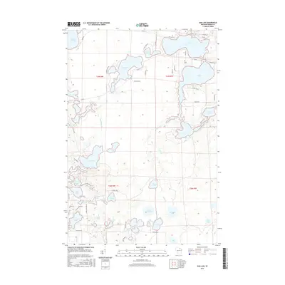
1971 Burrows Lake
Oneida County, WI
1971 Lac Du Flambeau SW
Oneida County, WI

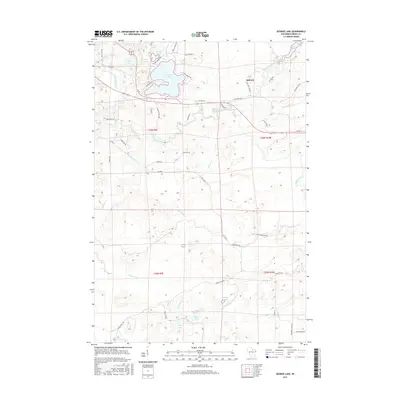
1971 Mercer Lake
Oneida County, WI

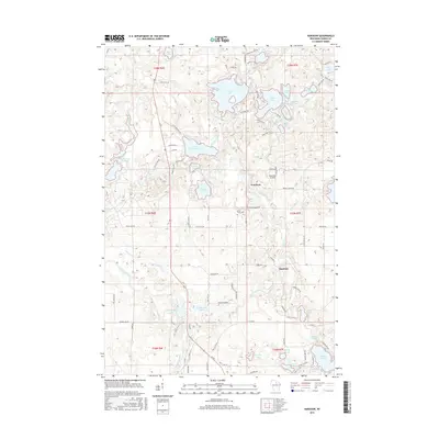
1971 Pier Lake
Oneida County, WI

1971 Tripoli
Oneida County, WI

1982 George Lake
Oneida County, WI

1982 Harshaw
Oneida County, WI

1982 Hazelhurst
Oneida County, WI

1982 Heafford Junction
Oneida County, WI

1982 Lake Julia
Oneida County, WI

1982 Mc Naughton
Oneida County, WI

1982 Moen Lake
Oneida County, WI

1982 Woodboro
Oneida County, WI
2010 Bradley
Oneida County, WI
2010 Burrows Lake
Oneida County, WI
2010 Dam Lake
Oneida County, WI
2010 George Lake
Oneida County, WI
2010 Harshaw
Oneida County, WI
2010 Hazelhurst
Oneida County, WI
2010 Heafford Junction
Oneida County, WI
2010 Lac du Flambeau SW
Oneida County, WI
2010 Lake Julia
Oneida County, WI
2010 McNaughton
Oneida County, WI
2010 Mercer Lake
Oneida County, WI
2010 Moen Lake
Oneida County, WI
2010 Monico
Oneida County, WI
2010 Nashville
Oneida County, WI
2010 Pier Lake
Oneida County, WI
2010 Starks
Oneida County, WI
2010 Sugar Camp
Oneida County, WI
2010 Tripoli
Oneida County, WI
2010 Woodboro
Oneida County, WI
2011 Julia Lake
Oneida County, WI
2011 Monico NE
Oneida County, WI
2013 Bradley
Oneida County, WI
2013 Burrows Lake
Oneida County, WI
2013 Dam Lake
Oneida County, WI
2013 George Lake
Oneida County, WI
2013 Harshaw
Oneida County, WI
2013 Hazelhurst
Oneida County, WI
2013 Heafford Junction
Oneida County, WI
2013 Julia Lake
Oneida County, WI
2013 Lac du Flambeau SW
Oneida County, WI
2013 Lake Julia
Oneida County, WI
2013 McNaughton
Oneida County, WI
2013 Mercer Lake
Oneida County, WI
2013 Moen Lake
Oneida County, WI
2013 Monico NE
Oneida County, WI
2013 Monico
Oneida County, WI
2013 Nashville
Oneida County, WI
2013 Pier Lake
Oneida County, WI
2013 Starks
Oneida County, WI
2013 Sugar Camp
Oneida County, WI
2013 Tripoli
Oneida County, WI
2013 Woodboro
Oneida County, WI
2015 Bradley
Oneida County, WI
2015 Burrows Lake
Oneida County, WI
2015 Dam Lake
Oneida County, WI
2015 George Lake
Oneida County, WI
2015 Harshaw
Oneida County, WI
2015 Hazelhurst
Oneida County, WI
2015 Heafford Junction
Oneida County, WI
2015 Julia Lake
Oneida County, WI
2015 Lac du Flambeau SW
Oneida County, WI
2015 Lake Julia
Oneida County, WI
2015 McNaughton
Oneida County, WI
2015 Mercer Lake
Oneida County, WI
2015 Moen Lake
Oneida County, WI
2015 Monico NE
Oneida County, WI
2015 Monico
Oneida County, WI
2015 Nashville
Oneida County, WI
2015 Pier Lake
Oneida County, WI
2015 Starks
Oneida County, WI
2015 Sugar Camp
Oneida County, WI
2015 Tripoli
Oneida County, WI
2015 Woodboro
Oneida County, WI
2018 Bradley
Oneida County, WI
2018 Burrows Lake
Oneida County, WI
2018 Dam Lake
Oneida County, WI
2018 George Lake
Oneida County, WI
2018 Harshaw
Oneida County, WI
2018 Hazelhurst
Oneida County, WI
2018 Heafford Junction
Oneida County, WI
2018 Julia Lake
Oneida County, WI
2018 Lac du Flambeau SW
Oneida County, WI
2018 Lake Julia
Oneida County, WI
2018 McNaughton
Oneida County, WI
2018 Mercer Lake
Oneida County, WI
2018 Moen Lake
Oneida County, WI
2018 Monico NE
Oneida County, WI
2018 Monico
Oneida County, WI
2018 Nashville
Oneida County, WI
2018 Pier Lake
Oneida County, WI
2018 Starks
Oneida County, WI
2018 Sugar Camp
Oneida County, WI
2018 Tripoli
Oneida County, WI
2018 Woodboro
Oneida County, WI

2022 Bradley
Oneida County, WI

2022 Burrows Lake
Oneida County, WI

2022 Dam Lake
Oneida County, WI

2022 George Lake
Oneida County, WI

2022 Harshaw
Oneida County, WI

2022 Hazelhurst
Oneida County, WI

2022 Heafford Junction
Oneida County, WI

2022 Julia Lake
Oneida County, WI

2022 McNaughton
Oneida County, WI

2022 Mercer Lake
Oneida County, WI

2022 Moen Lake
Oneida County, WI

2022 Monico NE
Oneida County, WI

2022 Monico
Oneida County, WI

2022 Nashville
Oneida County, WI

2022 Pier Lake
Oneida County, WI

2022 Starks
Oneida County, WI

2022 Sugar Camp
Oneida County, WI

2022 Tripoli
Oneida County, WI

2022 Woodboro
Oneida County, WI

2023 Lac du Flambeau SW
Oneida County, WI

2023 Lake Julia
Oneida County, WI