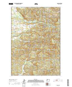
2020 Map of Lacomb
USGS Topo · Published 2020About this map
Lacomb and the neighboring locale of Fords Mill anchor this part of Linn County, where agricultural valleys meet the foothills of the Cascades. The landscape is defined by a dense network of water systems, from the artificial Lacomb Irrigation Canal and Hoerauf Reservoir to the natural winding paths of Crabtree Creek and Hamilton Creek. Cultural landmarks such as the Weddle Covered Bridge near Carter Creek highlight the region's preservation of its local heritage.
Find a feature on this map
54 named features on this map. Tap any name to fly to it.
Don’t see what you’re looking for? This feature index may not catch every label — zoom into the map to look around manually.
Map Details
Editions of this 2020 Lacomb Map
This is the sole edition of this map. No revisions or reprints were ever made.
Other maps of this area

1921 · Brownsville
USGS Topo · 1:62,500

1921 · Lebanon
USGS Topo · 1:62,500

1922 · Lebanon
USGS Topo · 1:48,000

1924 · Lebanon
USGS Topo · 1:62,500

1940 · Lebanon
USGS Topo · 1:62,500

1944 · Lebanon
USGS Topo · 1:62,500

1950 · Brownsville
USGS Topo · 1:62,500

1951 · Sweet Home
USGS Topo · 1:62,500

1951 · Snow Peak
USGS Topo · 1:62,500

1952 · Brownsville
USGS Topo · 1:62,500