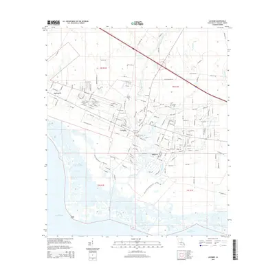
2015 Map of Lacombe
USGS Topo · Published 2015About this map
Lacombe and its surrounding wetlands occupy a critical stretch of the northern Lake Pontchartrain shoreline in St. Tammany Parish. This 2015 update documents the intricate network of waterways including Lacombe Bayou, Big Br Bayou, and Cane Bayou, which drain into the lake near Goose Point. The settlement patterns here are deeply rooted in local family history, as evidenced by numerous small burial grounds such as Toomer Memorial Cem, Seghors Cem, Cousin Cem, and James Todd Cem. These features, along with the community of Oaklawn, illustrate the coastal development and residential expansion into the piney woods and marshes of the Northshore. The landscape transitions from the developed streets of Big Branch to the protected wetlands of Bayou Des Mats, reflecting the region's balance between residential growth and environmental preservation.
Find a feature on this map
172 named features on this map. Tap any name to fly to it.
Don’t see what you’re looking for? This feature index may not catch every label — zoom into the map to look around manually.
Map Details
Editions of this 2015 Lacombe Map
This is the sole edition of this map. No revisions or reprints were ever made.
Other maps of this area

1891 · Spanish Fort
USGS Topo · 1:62,500

1892 · Chef Menteur
USGS Topo · 1:62,500

1935 · Slidell
USGS Topo · 1:62,500

1935 · Covington
USGS Topo · 1:62,500

1936 · North Shore
USGS Topo · 1:31,680

1936 · South Point
USGS Topo · 1:31,680

1936 · Chef Menteur
USGS Topo · 1:62,500

1936 · Spanish Fort
USGS Topo · 1:62,500

1939 · Slidell
USGS Topo · 1:62,500

1939 · Covington
USGS Topo · 1:62,500