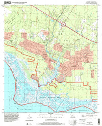
1998 Map of Lacombe
USGS Topo · Published 2001About this map
Bayou Lacombe and its surrounding marshlands define this late-20th-century landscape on the northern shores of Lake Pontchartrain. The settlement of Lacombe serves as a central hub, flanked by the sprawling Big Branch Marsh National Wildlife Refuge and the State Game Refuge. This map illustrates the transition from coastal wilderness to institutional and residential development, most notably at the Southeast Louisiana State Hospital grounds and the various religious and educational centers like Carmel Convent, Holy Redeemer College, and the Chahta-Ima High Sch.
Find a feature on this map
29 named features on this map. Tap any name to fly to it.
Don’t see what you’re looking for? This feature index may not catch every label — zoom into the map to look around manually.
Map Details
Editions of this 1998 Lacombe Map
This is the sole edition of this map. No revisions or reprints were ever made.
Other maps of this area

1891 · Spanish Fort
USGS Topo · 1:62,500

1892 · Chef Menteur
USGS Topo · 1:62,500

1935 · Slidell
USGS Topo · 1:62,500

1935 · Covington
USGS Topo · 1:62,500

1936 · North Shore
USGS Topo · 1:31,680

1936 · South Point
USGS Topo · 1:31,680

1936 · Chef Menteur
USGS Topo · 1:62,500

1936 · Spanish Fort
USGS Topo · 1:62,500

1939 · Slidell
USGS Topo · 1:62,500

1939 · Covington
USGS Topo · 1:62,500