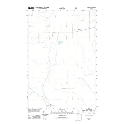
2011 Map of Ladoga
USGS Topo · Published 2011About this map
Sundell and Rumely sit along a central east-west transit corridor, defining the settled character of this northern Michigan landscape. This 2011 survey documents a region defined by its hydrography, where the Laughing Whitefish River and West Branch Whitefish River carve through the terrain. The small settlements of Dorsey and Ladoga are interconnected by a grid of named local roads, many bearing family names like Elmer Johnson Rd and Ikkala Rd, which suggest the deep roots of the local community. To the south, the community of Kiva marks a transition point near Huber Creek. The land is heavily partitioned by various tributaries, including Slapneck Creek, Dexter Creek, and Scott Creek, which feed into the larger river systems. This map serves as a detailed record of rural infrastructure and natural drainage before further modern development altered these traditional Marquette County townships.
Find a feature on this map
47 named features on this map. Tap any name to fly to it.
Don’t see what you’re looking for? This feature index may not catch every label — zoom into the map to look around manually.
Map Details
Editions of this 2011 Ladoga Map
This is the sole edition of this map. No revisions or reprints were ever made.
Other maps of this area

1932 · Skandia SW
USGS Topo · 1:31,680

1932 · Rock NE
USGS Topo · 1:31,680

1932 · Skandia SE
USGS Topo · 1:31,680

1932 · Skandia NE
USGS Topo · 1:31,680

1932 · Rock NW
USGS Topo · 1:31,680

1950 · Skandia NW
USGS Topo · 1:31,680

1958 · Trenary
USGS Topo · 1:62,500

1958 · Au Train
USGS Topo · 1:62,500

1958 · Skandia
USGS Topo · 1:62,500
1958 · Rock
USGS Topo · 1:62,500