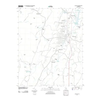
2011 Map of LaFayette
USGS Topo · Published 2011About this map
Blaylock Mill and its associated Blaylock Mill Pond sit along the Chattooga River south of the main settlement, reflecting the area's agricultural and industrial ties to local waterpower. This 2011 survey of the region surrounding LaFayette shows a landscape defined by parallel ridges and valleys, including Straight Gut Valley and Burnt Mill Valley. The town's growth is visible in the suburban expansion of neighborhoods like Oak Park, Skyline Heights, and Fairview Heights, while rural continuity is maintained through numerous family burial grounds such as Shaw Cemetery and Williams Cemetery. Significant industrial and infrastructure landmarks include the Walker County Quarry near Marsh Crossing and the Barwick Lafayette Airport. The western edge of the quadrangle is dominated by the steep terrain of The Pocket and Dug Gap, illustrating the natural barriers that have long shaped transportation routes like Estelle Mines Rd and Trion Hwy.
Find a feature on this map
106 named features on this map. Tap any name to fly to it.
Don’t see what you’re looking for? This feature index may not catch every label — zoom into the map to look around manually.
Map Details
Editions of this 2011 LaFayette Map
This is the sole edition of this map. No revisions or reprints were ever made.
Other maps of this area

1886 · Ringgold
USGS Topo · 1:125,000

1892 · Ringgold
USGS Topo · 1:125,000

1935 · Catlett
USGS Topo · 1:24,000

1935 · Durham
USGS Topo · 1:24,000

1935 · Nickajack Gap
USGS Topo · 1:24,000

1936 · Kensington
USGS Topo · 1:24,000

1936 · Estelle
USGS Topo · 1:24,000

1936 · Dougherty Gap
USGS Topo · 1:24,000
1936 · Cedar Grove
USGS Topo · 1:24,000

1946 · Kensington
USGS Topo · 1:24,000