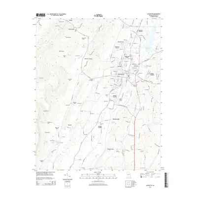
2014 Map of LaFayette
USGS Topo · Published 2014About this map
LaFayette sits as the central hub of this northern Georgia landscape, where the valley floor meets the significant rise of Pigeon Mtn and Shinbone Ridge. The map documents a blend of residential expansion in neighborhoods like Dogwood Circle, Winwood Forest, and Skyline Heights alongside enduring agricultural and industrial sites. Water management is a visible priority for the community, evidenced by the LaFayette City Reservoir, Wilson Ponds, and several localized lakes such as Dickson Lake and Chandler Lake.
Find a feature on this map
180 named features on this map. Tap any name to fly to it.
Don’t see what you’re looking for? This feature index may not catch every label — zoom into the map to look around manually.
Map Details
Editions of this 2014 LaFayette Map
This is the sole edition of this map. No revisions or reprints were ever made.
Other maps of this area

1886 · Ringgold
USGS Topo · 1:125,000

1892 · Ringgold
USGS Topo · 1:125,000

1935 · Catlett
USGS Topo · 1:24,000

1935 · Durham
USGS Topo · 1:24,000

1935 · Nickajack Gap
USGS Topo · 1:24,000

1936 · Kensington
USGS Topo · 1:24,000

1936 · Estelle
USGS Topo · 1:24,000

1936 · Dougherty Gap
USGS Topo · 1:24,000
1936 · Cedar Grove
USGS Topo · 1:24,000

1946 · Kensington
USGS Topo · 1:24,000