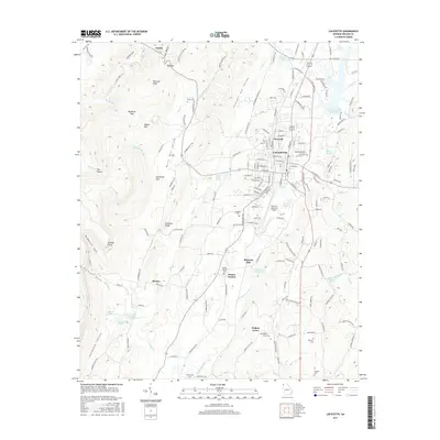
2017 Map of LaFayette
USGS Topo · Published 2017About this map
The town of Lafayette serves as the focal point for this Walker County survey, positioned where the valley floor meets the dramatic rise of Pigeon Mtn and Shinbone Ridge. The landscape is defined by the transition from the concentrated street grid of the city to the rural expanses of Burnt Mill Valley and Straight Gut Valley. Water systems are integral to the area's layout, seen in the Lafayette City Reservoir and the Chattooga River which flows south past Mount Carmel. The presence of Blaylock Mill and the Barwick Lafayette Airport illustrates the blend of traditional industry and modern infrastructure. Smaller outlying communities like Estelle and Bronco are linked by a network of rural routes, including Estelle Mines Rd, which points to the region's mineral extraction history.
Find a feature on this map
175 named features on this map. Tap any name to fly to it.
Don’t see what you’re looking for? This feature index may not catch every label — zoom into the map to look around manually.
Map Details
Editions of this 2017 LaFayette Map
This is the sole edition of this map. No revisions or reprints were ever made.
Other maps of this area

1886 · Ringgold
USGS Topo · 1:125,000

1892 · Ringgold
USGS Topo · 1:125,000

1935 · Catlett
USGS Topo · 1:24,000

1935 · Durham
USGS Topo · 1:24,000

1935 · Nickajack Gap
USGS Topo · 1:24,000

1936 · Kensington
USGS Topo · 1:24,000

1936 · Estelle
USGS Topo · 1:24,000

1936 · Dougherty Gap
USGS Topo · 1:24,000
1936 · Cedar Grove
USGS Topo · 1:24,000

1946 · Kensington
USGS Topo · 1:24,000