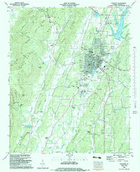
1983 Map of Lafayette
USGS Topo · Published 1983About this map
The Lafayette area during the early 1980s is defined by its position between the steep elevations of Pigeon Mountain and the broad valley floors of the Chattooga River and Peavine Creek. This survey reveals a landscape of limestone features and karst topography, including the Cornfield Sink and several notable cavern systems like Ellison Cave and Pettyjohn Cave within the Shinbone Ridge and Burnt Mill Valley corridors.
Find a feature on this map
89 named features on this map. Tap any name to fly to it.
Don’t see what you’re looking for? This feature index may not catch every label — zoom into the map to look around manually.
Map Details
Editions of this 1983 Lafayette Map
This is the sole edition of this map. No revisions or reprints were ever made.
Other maps of this area

1886 · Ringgold
USGS Topo · 1:125,000

1892 · Ringgold
USGS Topo · 1:125,000

1935 · Catlett
USGS Topo · 1:24,000

1935 · Durham
USGS Topo · 1:24,000

1935 · Nickajack Gap
USGS Topo · 1:24,000

1936 · Kensington
USGS Topo · 1:24,000

1936 · Estelle
USGS Topo · 1:24,000
1936 · Dougherty Gap
USGS Topo · 1:24,000
1936 · Cedar Grove
USGS Topo · 1:24,000

1946 · Kensington
USGS Topo · 1:24,000