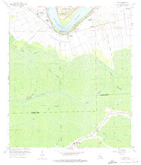
1962 Map of Lagan
USGS Topo · Published 1975About this map
Mississippi River riverbanks define the life and economy of this Louisiana landscape in the early 1960s, where traditional sugar estates like Oak Alley and St James Plantation sit alongside more modern infrastructure. The winding levee system protects established settlements such as College Point and Lagan, while the Texas and Pacific railroad tracks trace the northern shoreline. Inland, the terrain transitions sharply into a network of wetlands and waterways, including the St James Canal and Bayou Chevreuil. An extensive elevated aqueduct system cuts across the southern parish line into Lafourche Parish, signifying the complex water management required in this low-lying area. Local history is anchored by sites such as Manresa Retreat and rural landmarks like St Lukes Ch and the Trosclair Cem, which mark the community's presence amid the gas and oil fields.
Find a feature on this map
39 named features on this map. Tap any name to fly to it.
Don’t see what you’re looking for? This feature index may not catch every label — zoom into the map to look around manually.
Map Details
Editions of this 1962 Lagan Map
4 editions found
Other maps of this area

1892 · Lac Des Allemands
USGS Topo · 1:62,500

1892 · Mount Airy
USGS Topo · 1:62,500

1892 · Donaldsonville
USGS Topo · 1:62,500

1892 · Thibodaux
USGS Topo · 1:62,500

1927 · Thibodaux NW
USGS Topo · 1:31,680

1932 · Lac Des Allemands NW
USGS Topo · 1:31,680

1932 · Lac Des Allemands SW
USGS Topo · 1:31,680

1932 · Thibodaux NE
USGS Topo · 1:31,680

1932 · Thibodaux SE
USGS Topo · 1:31,680

1932 · Thibodaux SW
USGS Topo · 1:31,680