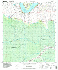
1998 Map of Lagan
USGS Topo · Published 2000About this map
Historic River Road plantations line the banks of the Mississippi River in this late-century record of St. James Parish. Iconic landmarks like Oak Alley, Bon Secours Plantation, and Laurel Ridge Plantation anchor the high ground along the levees, while the settlement of College Point sits at a prominent bend in the river near St Paul Ch. Moving away from the river, the landscape transitions into the vast wetlands and cypress swamps of the St James Parish and Lafourche Parish border. This area is defined by a complex network of waterways including Bayou Citamon, Culgrass Willow Island Bayou, and Petit Chackbay. The map also documents the industrial presence in the basin, featuring an extensive Gas and Oil Field and scattered infrastructure such as a Pumping Station and various oil wells near the community of Chackbay.
Find a feature on this map
31 named features on this map. Tap any name to fly to it.
Don’t see what you’re looking for? This feature index may not catch every label — zoom into the map to look around manually.
Map Details
Editions of this 1998 Lagan Map
This is the sole edition of this map. No revisions or reprints were ever made.
Other maps of this area

1892 · Lac Des Allemands
USGS Topo · 1:62,500

1892 · Mount Airy
USGS Topo · 1:62,500

1892 · Donaldsonville
USGS Topo · 1:62,500

1892 · Thibodaux
USGS Topo · 1:62,500

1927 · Thibodaux NW
USGS Topo · 1:31,680

1932 · Lac Des Allemands NW
USGS Topo · 1:31,680

1932 · Lac Des Allemands SW
USGS Topo · 1:31,680

1932 · Thibodaux NE
USGS Topo · 1:31,680

1932 · Thibodaux SE
USGS Topo · 1:31,680

1932 · Thibodaux SW
USGS Topo · 1:31,680