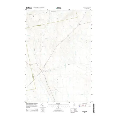
2014 Map of Lagrange
USGS Topo · Published 2014About this map
The settlement of Lagrange sits at the junction of several regional routes, where Mill St and Howland Rd meet near the geographic center of this Maine landscape. This area is defined by an intricate network of waterways, with Birch Stream and Dead Stream cutting through the southern lowlands while Cold Stream and Roberts Rocky Brook flow through the northern reaches. The terrain transitions from the wetland-heavy basins in the south to more prominent elevations like Paddy Hill in the northwest, near Medford Center. This 2014 survey documents a rural environment where land use is tied closely to the natural drainage patterns, as evidenced by the way local roads such as Brimstone Rd and Fire Tower Rd navigate the more stable ground between the numerous brooks and marshy stretches. Further north, the Medford Cem serves as a small but significant landmark for those tracing local history near the Medford Center settlement.
Find a feature on this map
29 named features on this map. Tap any name to fly to it.
Don’t see what you’re looking for? This feature index may not catch every label — zoom into the map to look around manually.
Map Details
Editions of this 2014 Lagrange Map
This is the sole edition of this map. No revisions or reprints were ever made.
Other maps of this area

1917 · Passadumkeag
USGS Topo · 1:62,500

1933 · Boyd Lake
USGS Topo · 1:62,500

1942 · Lincoln
USGS Topo · 1:62,500

1947 · Schoodic
USGS Topo · 1:62,500

1949 · Schoodic
USGS Topo · 1:62,500

1951 · Boyd Lake
USGS Topo · 1:50,000

1954 · Millinocket
USGS Topo · 1:250,000

1955 · Boyd Lake
USGS Topo · 1:62,500

1957 · Lincoln
USGS Topo · 1:62,500

1958 · Millinocket
USGS Topo · 1:250,000