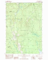
1983 Map of Lagrange
USGS Topo · Published 1984About this map
Lagrange and the northern reaches of Medford Center anchor this 1980s landscape, defined by the winding course of Cold Stream and its numerous tributaries. The village of Lagrange is shown as a concentrated cluster of structures at a critical junction of local transit and the Bangor and Aroostook railroad, which cuts a straight path through the wooded terrain. This area in Penobscot County shows a clear reliance on the natural landscape for local industry and infrastructure, evidenced by the presence of a Gravel Pit and a designated dump site outside the main settlement.
Find a feature on this map
27 named features on this map. Tap any name to fly to it.
Don’t see what you’re looking for? This feature index may not catch every label — zoom into the map to look around manually.
Map Details
Editions of this 1983 Lagrange Map
This is the sole edition of this map. No revisions or reprints were ever made.
Other maps of this area

1917 · Passadumkeag
USGS Topo · 1:62,500

1933 · Boyd Lake
USGS Topo · 1:62,500

1942 · Lincoln
USGS Topo · 1:62,500

1947 · Schoodic
USGS Topo · 1:62,500

1949 · Schoodic
USGS Topo · 1:62,500

1951 · Boyd Lake
USGS Topo · 1:50,000

1954 · Millinocket
USGS Topo · 1:250,000

1955 · Boyd Lake
USGS Topo · 1:62,500

1957 · Lincoln
USGS Topo · 1:62,500

1958 · Millinocket
USGS Topo · 1:250,000