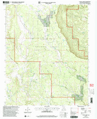
2002 Map of Laguna Ortiz
USGS Topo · Published 2003About this map
Hurtado Mesa dominates the eastern horizon of this landscape, where the high desert terrain transitions into the protected timberlands of the Santa Fe National Forest. This 2002 revision, based on earlier topographic data and mid-1990s imagery, documents a land defined by water management in a semi-arid climate. A network of drainage features like Arroyo de Chamizal and Arroyo El Bragoso carve through the earth, feeding into numerous livestock and wildlife sources such as Laguna Ortiz, Madrid Tank, and the Wildlife Trick Tank.
Find a feature on this map
29 named features on this map. Tap any name to fly to it.
Don’t see what you’re looking for? This feature index may not catch every label — zoom into the map to look around manually.
Map Details
Editions of this 2002 Laguna Ortiz Map
This is the sole edition of this map. No revisions or reprints were ever made.
Other maps of this area

1890 · Bernal
USGS Topo · 1:125,000

1891 · Bernal
USGS Topo · 1:125,000

1894 · Bernal
USGS Topo · 1:125,000

1894 · Lamy
USGS Topo · 1:125,000

1954 · Santa Fe
USGS Topo · 1:250,000

1958 · Santa Fe
USGS Topo · 1:250,000

1960 · Villanueva
USGS Topo · 1:62,500

1963 · Aurora
USGS Topo · 1:24,000
1966 · Mesa El Toro
USGS Topo · 1:24,000
1966 · Laguna Ortiz
USGS Topo · 1:24,000