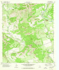
1974 Map of Laguna
USGS Topo · Published 1977About this map
The Nueces River winds through this rugged portion of the Edwards Plateau, carving a dramatic landscape of bluffs and named peaks. This 1974 field check reveals a rural Texan environment where land ownership and topography are intertwined, noted by the inclusion of selected fence lines and an indefinite boundary between Kinney and Uvalde counties. Local history is anchored by the Live Oak School and the Yancy Cem, while the small settlement of Laguna sits near the eastern edge of the survey area.
Find a feature on this map
31 named features on this map. Tap any name to fly to it.
Don’t see what you’re looking for? This feature index may not catch every label — zoom into the map to look around manually.
Map Details
Editions of this 1974 Laguna Map
This is the sole edition of this map. No revisions or reprints were ever made.
Other maps of this area

1893 · Nueces
USGS Topo · 1:125,000

1896 · Nueces
USGS Topo · 1:125,000

1896 · Brackett
USGS Topo · 1:125,000

1897 · Brackett
USGS Topo · 1:125,000

1898 · Uvalde
USGS Topo · 1:125,000

1899 · Uvalde
USGS Topo · 1:125,000

1938 · Turkey Mountain
USGS Topo · 1:48,000

1943 · Turkey Mountain
USGS Topo · 1:62,500

1944 · Barksdale
USGS Topo · 1:62,500

1954 · San Antonio
USGS Topo · 1:250,000