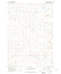
1971 Map of Lahti Butte
USGS Topo · Published 1974About this map
Pleasant Valley stretches across the northern reaches of this Harding County landscape, a terrain defined by its drainage basins and isolated high points. The namesake Lahti Butte rises in the east, providing a distinct landmark overlooking the meandering course of Jones Creek. This 1971 field-checked survey reveals an era of ranching and early resource extraction, indicated by the presence of a lone Oil Well and a Gravel Pit near the headwaters of Cottonwood Creek. The small Travers Landing Strip sits in the central uplands, suggesting the necessity of light aircraft for traversing this expansive rangeland. Water is the primary architect of the geography here, with several named ephemeral streams including Rush Creek and Dry House Cr carving paths through the valley floors between Mud Butte and the surrounding high ground.
Find a feature on this map
10 named features on this map. Tap any name to fly to it.
Don’t see what you’re looking for? This feature index may not catch every label — zoom into the map to look around manually.
Map Details
Editions of this 1971 Lahti Butte Map
This is the sole edition of this map. No revisions or reprints were ever made.
Other maps of this area

1935 · Buffalo
USGS Topo · 1:125,000

1954 · Lemmon
USGS Topo · 1:250,000

1957 · Lemmon
USGS Topo · 1:250,000

1969 · Ladner
USGS Topo · 1:24,000

1969 · Ladner SE
USGS Topo · 1:24,000

1971 · Buffalo
USGS Topo · 1:24,000

1971 · McKenzie Butte
USGS Topo · 1:24,000

1971 · Saddle Butte
USGS Topo · 1:24,000

1973 · Gallup Creek
USGS Topo · 1:24,000

1974 · Pine Spring
USGS Topo · 1:24,000