1974 Map of Lake Abert
USGS Topo · Published 1994About this map
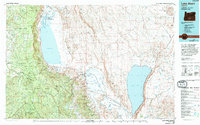
Summer Lake and Lake Abert dominate this high-desert landscape in south-central Oregon, illustrating a complex hydrological system of endorheic basins. The Chewaucan River flows through the extensive wetlands of the Upper Chewaucan Marsh and Lower Chewaucan Marsh before reaching the hypersaline waters of Lake Abert. The dramatic verticality of the region is defined by massive fault scarps, most notably the Abert Rim and Winter Ridge, which rise sharply above the basin floor.
Find a feature on this map
38 named features on this map. Tap any name to fly to it.
Don’t see what you’re looking for? This feature index may not catch every label — zoom into the map to look around manually.
Map Details
Editions of this 1974 Lake Abert Map
This is the sole edition of this map. No revisions or reprints were ever made.
Other maps of this area

1889 · Klamath
USGS Topo · 1:250,000

1894 · Klamath
USGS Topo · 1:250,000

1955 · Crescent
USGS Topo · 1:250,000

1955 · Klamath Falls
USGS Topo · 1:250,000

1955 · Burns
USGS Topo · 1:250,000

1955 · Adel
USGS Topo · 1:250,000

1957 · Adel
USGS Topo · 1:250,000

1957 · Crescent
USGS Topo · 1:250,000

1958 · Crescent
USGS Topo · 1:250,000

1958 · Klamath Falls
USGS Topo · 1:250,000