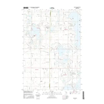
2017 Map of Lake Ann
USGS Topo · Published 2017About this map
Lake Ann sits at the heart of this glacial landscape on the border of Benzie and Grand Traverse counties, surrounded by a dense network of water bodies and early 21st-century residential expansion. Small clusters of development like Hardwood Acres and Maple Grove appear alongside established village centers at Interlochen and Bendon. The map illustrates a transition from the structured residential roads of Long Lake Township to the meandering courses of the Platte River and various wetlands. Genealogists will find significant value in the documentation of several local burial sites, including the Lake Ann Cem, New Inland Cem, Old Inland Cem, and Mount Hope Cem. The area is further defined by its recreational geography, featuring numerous islands such as Brush Island and Picnic Island within the larger lakes, and specialized paths like the Shore to Shore Trail crossing the terrain.
Find a feature on this map
182 named features on this map. Tap any name to fly to it.
Don’t see what you’re looking for? This feature index may not catch every label — zoom into the map to look around manually.
Map Details
Editions of this 2017 Lake Ann Map
This is the sole edition of this map. No revisions or reprints were ever made.
Other maps of this area

1954 · Traverse City
USGS Topo · 1:250,000

1956 · Kingsley
USGS Topo · 1:62,500

1956 · Thompsonville
USGS Topo · 1:62,500

1957 · Traverse City
USGS Topo · 1:62,500

1957 · Maple City
USGS Topo · 1:62,500

1958 · Traverse City
USGS Topo · 1:250,000

1976 · Thompsonville NE
USGS Topo · 1:24,000
1976 · Thompsonville SW
USGS Topo · 1:24,000

1976 · Thompsonville NW
USGS Topo · 1:24,000

1976 · Thompsonville SE
USGS Topo · 1:24,000
Featured Places
- Long Lake Charter Township, Long Lake Township
- Long Lake Township, MI
- Green Lake Township, MI
- Interlochen, Green Lake Township
- Hardwood Acres, MI