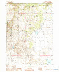
1990 Map of Lake Annie
USGS Topo · Published 1990About this map
The Warner Mountains dominate the western landscape of this high-altitude border region where California meets Oregon. This survey captures a terrain defined by its water management and drainage, where man-made infrastructure like the Schadler Ditch and Eightmile Ditch redirects runoff toward ranching interests. At the center of this activity is the Scammons Arrowhead Ranch, situated near the Schadler Reservoir and the expansive basin of Cow Head Lake. The map reveals a distinct naming convention for the local hydrology, with a series of drainages including Eightmile Creek, Ninemile Creek, Tenmile Creek, and Twelvemile Creek descending from the heights toward the Surprise Valley floor. This systematic nomenclature suggests early survey paths or distance markers along regional travel routes. To the south, Lake Annie sits tucked against the slopes, while the eastern flats are marked by the seasonal waters of Big Mud Lake.
Find a feature on this map
28 named features on this map. Tap any name to fly to it.
Don’t see what you’re looking for? This feature index may not catch every label — zoom into the map to look around manually.
Map Details
Editions of this 1990 Lake Annie Map
This is the sole edition of this map. No revisions or reprints were ever made.
Other maps of this area

1886 · Alturas
USGS Topo · 1:250,000

1889 · Long Valley
USGS Topo · 1:250,000

1892 · Alturas
USGS Topo · 1:250,000

1954 · Vya
USGS Topo · 1:250,000

1954 · Alturas
USGS Topo · 1:250,000

1955 · Klamath Falls
USGS Topo · 1:250,000

1955 · Adel
USGS Topo · 1:250,000

1957 · Adel
USGS Topo · 1:250,000

1958 · Alturas
USGS Topo · 1:250,000

1958 · Klamath Falls
USGS Topo · 1:250,000