
1967 Map of Lake Benton NW
USGS Topo · Published 1968About this map
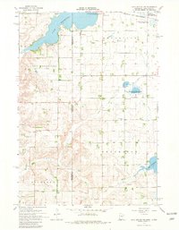
Lake Hendricks straddles the border of Minnesota and South Dakota, serving as the central geographic anchor for this prairie landscape in the late 1960s. The map illustrates a region defined by agricultural heritage and conservation efforts, with the Hendricks Corporate Boundary pressing against the lake's eastern shore. Several dedicated conservation zones appear across the terrain, including the Kvermo State Wildlife Management Area and the Shaokatan State Wildlife Management Area, which preserve the wetlands surrounding Lake Shaokatan.
Find a feature on this map
20 named features on this map. Tap any name to fly to it.
Don’t see what you’re looking for? This feature index may not catch every label — zoom into the map to look around manually.
Map Details
Editions of this 1967 Lake Benton NW Map
2 editions found
Other maps of this area

1953 · Watertown
USGS Topo · 1:250,000

1958 · Watertown
USGS Topo · 1:250,000

1967 · Lake Benton
USGS Topo · 1:24,000

1967 · Canby SE
USGS Topo · 1:24,000

1967 · Lake Benton SW
USGS Topo · 1:24,000

1967 · Hendricks
USGS Topo · 1:24,000

1967 · Lake Benton NE
USGS Topo · 1:24,000

1970 · White NE
USGS Topo · 1:24,000

1970 · Astoria
USGS Topo · 1:24,000
1972 · White SE
USGS Topo · 1:24,000