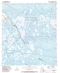
1994 Map of Lake Bully Camp
USGS Topo · Published 1994About this map
Pointe Au Chien State Wildlife Management Area dominates this coastal Louisiana landscape, where the boundary between Lafourche Parish and Terrebonne Parish winds through an intricate network of wetlands. The 1990s environment is defined by its industrial footprint, featuring numerous extractive sites such as the Bully Camp Gas and Oil Field and the Montegut Oil Field. Settlement is concentrated along the ridges of Bayou Pointe au Chien, where The Oak Ch and the Wildlife Management Area Headquarters serve as focal points for the local community. Water management and transport are critical to the region, as seen in the engineered paths of the Grand Bayou Canal and the Pipeline Canal. This survey illustrates the delicate balance between the natural marsh ecosystem and the extensive energy infrastructure that traverses Lake Bully Camp and Bayou Blue.
Find a feature on this map
24 named features on this map. Tap any name to fly to it.
Don’t see what you’re looking for? This feature index may not catch every label — zoom into the map to look around manually.
Map Details
Editions of this 1994 Lake Bully Camp Map
This is the sole edition of this map. No revisions or reprints were ever made.
Other maps of this area

1892 · Cut-Off
USGS Topo · 1:62,500

1892 · Houma
USGS Topo · 1:62,500

1894 · Lake Felicity
USGS Topo · 1:62,500

1894 · Dulac
USGS Topo · 1:62,500

1932 · Houma SE
USGS Topo · 1:31,680

1935 · Bourbeux
USGS Topo · 1:31,680

1935 · Viguerie Canal
USGS Topo · 1:31,680

1935 · Montegut
USGS Topo · 1:31,680

1935 · Bay Courant
USGS Topo · 1:31,680

1935 · Golden Meadow
USGS Topo · 1:31,680