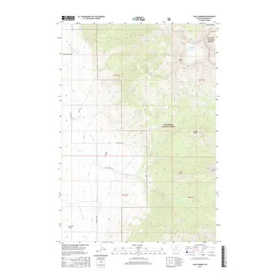
2017 Map of Lake Cameron
USGS Topo · Published 2017About this map
Beaverhead National Forest and Gallatin National Forest meet across the high-altitude terrain of the Madison Range in this modern topographic study. The landscape is defined by its water management and dramatic elevation, featuring the namesake Lake Cameron and the alpine Cedar Lake near Cedar Falls. Human impact on the land is visible through a network of irrigation systems such as Bear Cr Ditch and Indian Cr Ditch, which channel water from the peaks toward the Cameron Bench in the valley. For those researching local history or family genealogy, the Bear Creek Cem serves as a significant landmark near the transition from grazing lands to the forested slopes of Cedar Mtn and Black Mtn.
Find a feature on this map
35 named features on this map. Tap any name to fly to it.
Don’t see what you’re looking for? This feature index may not catch every label — zoom into the map to look around manually.
Map Details
Editions of this 2017 Lake Cameron Map
This is the sole edition of this map. No revisions or reprints were ever made.
Other maps of this area

1888 · Three Forks
USGS Topo · 1:250,000

1894 · Three Forks
USGS Topo · 1:250,000

1895 · Three Forks
USGS Topo · 1:250,000

1947 · Bozeman
USGS Topo · 1:250,000

1948 · Bozeman
USGS Topo · 1:250,000

1949 · Ennis
USGS Topo · 1:62,500

1950 · Cameron
USGS Topo · 1:62,500

1950 · Spanish Peaks
USGS Topo · 1:62,500

1950 · Sphinx Mountain
USGS Topo · 1:62,500

1955 · Bozeman
USGS Topo · 1:250,000