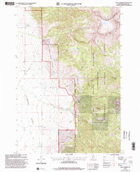
1997 Map of Lake Cameron
USGS Topo · Published 2002About this map
Cameron Bench dominates the western portion of this landscape, where the irrigation of the high plains is marked by the Storey Ditch and Indian Creek Ditch. To the east, the terrain rises sharply into the Madison Range, characterized by the high-altitude waters of Lake Cameron and Cedar Lake within the Lee Metcalf Wilderness (Taylor Hilgard Unit). The boundary between the open benchland and the forest highlights the distinct transition from agricultural utility to protected wilderness. Local history is anchored by a small Cem and a Gravel Pit near the transition zone, while the Bear Creek Wildlife Management Area underscores the region's focus on conservation. The complex drainage of Tolman Creek and the various forks of Bear Creek trace the movement of water from the peaks of Cedar Mountain down toward the Madison Valley.
Find a feature on this map
26 named features on this map. Tap any name to fly to it.
Don’t see what you’re looking for? This feature index may not catch every label — zoom into the map to look around manually.
Map Details
Editions of this 1997 Lake Cameron Map
This is the sole edition of this map. No revisions or reprints were ever made.
Other maps of this area

1888 · Three Forks
USGS Topo · 1:250,000

1894 · Three Forks
USGS Topo · 1:250,000

1895 · Three Forks
USGS Topo · 1:250,000

1947 · Bozeman
USGS Topo · 1:250,000

1948 · Bozeman
USGS Topo · 1:250,000

1949 · Ennis
USGS Topo · 1:62,500

1950 · Cameron
USGS Topo · 1:62,500

1950 · Spanish Peaks
USGS Topo · 1:62,500

1950 · Sphinx Mountain
USGS Topo · 1:62,500

1955 · Bozeman
USGS Topo · 1:250,000